Les données géospatiales ont quitté les laboratoires de cartographie pour s’infiltrer dans des domaines inattendus. Le jeu vidéo est l’un des plus frappants. Quand je travaille sur des projets liés à des systèmes d’information géographique, je constate régulièrement que les algorithmes de modélisation du terrain, les projections cartographiques et les données LiDAR nourrissent des univers interactifs que des millions de joueurs parcourent chaque jour. Ce croisement entre géomatique et industrie du jeu mérite une analyse sérieuse.
Quand la topographie devient terrain de jeu
La génération procédurale de terrain repose sur des principes directement empruntés à la cartographie physique. Les moteurs comme Unreal Engine ou Unity utilisent des heightmaps, c’est-à-dire des cartes d’altitude codées en niveaux de gris, dont la logique est identique à celle des modèles numériques de terrain (MNT) produits par des agences comme l’IGN.
Des studios comme Hello Games, avec No Man’s Sky, ont poussé cette logique à l’extrême. Leurs planètes générées algorithmiquement s’appuient sur des fonctions de bruit (Perlin, Simplex) qui imitent les processus géomorphologiques réels : érosion fluviale, dépôt sédimentaire, plissements tectoniques. Le résultat est un relief crédible parce qu’il suit les mêmes lois mathématiques que la nature.
MNT, LiDAR et photoréalisme
Le LiDAR, technologie massivement utilisée en géomatique pour produire des nuages de points 3D du territoire, fait désormais son entrée dans le pipeline de production des jeux. Microsoft Flight Simulator 2020 en est l’exemple le plus documenté : la plateforme Bing Maps a fourni des données altimétriques et photographiques couvrant la quasi-totalité des terres émergées. Le résultat en termes de fidélité topographique est sans précédent dans l’industrie.
Source de données
Usage en cartographie
Usage en jeu vidéo
MNT (Modèle Numérique de Terrain)
Relief, hydrologie, analyse de pentes
Génération de terrain, physique du sol
LiDAR
Cartographie 3D, forêt, bâti
Reconstruction d’environnements urbains
Orthophotographie
Fond de carte, mise à jour
Textures de surface réalistes
Données OSM
Réseaux routiers, POI
Génération de villes ouvertes
Ce tableau résume bien la porosité entre les deux disciplines. Les outils changent, la logique de représentation spatiale reste la même.
Les environnements immersifs et l’essor des plateformes interactives
La modélisation spatiale influence des secteurs bien au-delà du jeu d’aventure ou de simulation. Les plateformes de jeux d’argent en ligne ont elles aussi intégré des techniques de conception d’espace virtuel pour offrir des expériences immersives. Quand j’analyse ces environnements, je retrouve les mêmes préoccupations qu’en cartographie : la lisibilité, la navigation intuitive, la densité d’information à l’écran.
Les opérateurs qui réussissent conçoivent leurs interfaces comme on conçoit une carte thématique : chaque élément a une place, une hiérarchie visuelle, une fonction précise. Le pampago casino illustre cette approche dans le secteur des jeux d’argent en ligne, où l’architecture de la plateforme permet aux joueurs de naviguer entre les machines à sous, les jeux de table avec croupier en direct, et les options de paris sportifs sans friction. Les mécaniques de bonus de dépôt, les conditions de mise affichées clairement, et les outils de jeu responsable comme l’auto-exclusion montrent comment un opérateur sérieux structure l’expérience pour protéger les joueurs tout en maximisant la fluidité de navigation.
La géolocalisation au coeur des systèmes de conformité
La géolocalisation joue un rôle réglementaire direct dans le jeu en ligne. Les opérateurs sous licence utilisent des API de géolocalisation IP combinées à des bases de données de polygones juridictionnels pour restreindre l’accès selon le pays ou la région de l’utilisateur. C’est une application directe du géotraitement : un point (l’adresse IP) testé contre un polygone (la zone réglementaire).
En France, l’Autorité Nationale des Jeux (ANJ) impose des contraintes territoriales strictes. Les plateformes conformes intègrent ces contraintes via des couches de données spatiales mises à jour régulièrement, exactement comme un SIG met à jour ses couches administratives.
Données spatiales ouvertes et game design collaboratif
L’OpenStreetMap (OSM) est devenu une matière première pour des studios indépendants. Des jeux comme Mapcrunch ou des expériences de réalité augmentée comme Pokémon GO exploitent directement les données OSM pour construire leurs mondes.
Voici les types de données géospatiales ouvertes les plus exploitées par l’industrie du jeu :
Réseaux routiers et sentiers pour la génération de chemins navigables
Emprise des bâtiments pour la reconstruction urbaine procédurale
Données d’élévation SRTM (NASA) pour les terrains grande échelle
Hydrographie pour les rivières, lacs et littoraux dynamiques
Zones de végétation pour la distribution automatique de biomes
Ces données sont accessibles via des APIs standardisées que les développeurs interrogent de la même façon qu’un géomaticien interroge un serveur WMS ou WFS.
Géoportail et ses usages inattendus
En France, Géoportail offre un accès à des décennies de photographies aériennes historiques et de cartes topographiques scannées. J’ai vu plusieurs studios utiliser ces archives pour reconstituer des environnements historiques précis, notamment pour des jeux se déroulant sur le territoire français. La carte d’État-Major du XIXe siècle, disponible en flux WMTS sur Géoportail, a servi de référence à plusieurs projets de reconstitution médiévale.
C’est une illustration directe de la valeur des données géospatiales patrimoniales au-delà de leur usage traditionnel en aménagement du territoire ou en gestion environnementale.
Ce que la géomatique apporte au game design de demain
Les jumeaux numériques urbains, comme ceux développés par des villes comme Singapour ou Rennes, préfigurent la prochaine génération de jeux massivement multijoueurs. Ces modèles 3D temps réel de l’espace urbain, alimentés par des capteurs IoT et des flux de données géospatiales continues, seront la base des métavers les plus crédibles.
Je pense que les professionnels du SIG ont un rôle actif à jouer dans cette évolution. La rigueur méthodologique de la géomatique, sa culture de la précision et de la cohérence spatiale, est exactement ce qui manque à beaucoup de productions vidéoludiques dès qu’elles cherchent à représenter le monde réel.
Les compétences en modélisation 3D du terrain, en projection cartographique et en gestion de données vecteur et raster sont transférables vers des pipelines de production interactifs. Si vous travaillez dans le SIG et que vous cherchez à diversifier vos applications, le secteur du jeu vidéo recrute des profils géomatiques, souvent sous l’intitulé “technical designer” ou “world builder”.
Les données géospatiales ont toujours raconté des histoires sur l’espace. Aujourd’hui, elles construisent les espaces dans lesquels les histoires se déroulent.
Je me souviens très bien de la première fois où j’ai vu ma propre rue apparaître dans un jeu. La carte n’était plus un simple décor abstrait : c’était mon quartier, mes chemins, mes repères, transformés en terrain d’aventure. Depuis, une question me fascine : comment des jeux de données géospatiales peuvent donner vie à des expériences comme Dino Mystake, qui semblent coller au monde réel tout en le réinventant. Dans cet article, je te montre comment ces données brutes deviennent un moteur de gameplay, de narration et de game design.
Comprendre Ce Que Sont Les Jeux De Données Géospatiales
Définition Des Données Géospatiales Et De Leurs Sources
Je begin par la base : un jeu de données géospatiales, c’est un ensemble de données lié à une position précise sur la Terre. Chaque objet possède des coordonnées. Cela peut être un point, une ligne ou une surface.
Les exemples sont nombreux :
un point GPS pour un arrêt de bus :
une ligne pour une route ou un sentier :
un polygone pour un parc, un lac ou un bâtiment.
Ces données viennent de plusieurs sources :
OpenStreetMap (OSM) pour les routes, bâtiments, points d’intérêt :
données d’élévation comme SRTM ou autres MNT (modèles numériques de terrain) pour le relief :
services d’imagerie satellite pour repérer les zones urbaines, agricoles, forestières :
bases publiques fournies par les États ou les collectivités (cadastre, zones protégées, etc.).
Pour un jeu comme Dino Mystake, ces jeux de données offrent une sorte de squelette du monde réel. Je peux m’en servir comme base pour placer les routes du joueur, ses parcs, ses lacs, et tout ce qui peut devenir décor ou mécanique de jeu.
Types De Données Utiles Pour Un Jeu Comme Dino Mystake
Je distingue plusieurs familles de données qui servent bien un jeu géolocalisé.
Réseau viaire et chemins
Routes, rues, pistes cyclables, sentiers. Dino Mystake peut les utiliser pour définir les déplacements possibles. Je peux, par exemple, faire apparaître plus d’événements près des axes fréquentés.
Points d’intérêt (POI)
Restaurants, monuments, arrêts de bus, musées, pharmacies, écoles. Ces points deviennent des “stations” dans le jeu : lieux d’événements, de quêtes ou de récompenses.
Zones et surfaces
Parcs, forêts, plans d’eau, zones industrielles, quartiers résidentiels. Je peux transformer ces zones en biomes dans Dino Mystake. Un parc devient une zone de créatures rares, un lac une zone de ressources spéciales.
Relief et altitude
Courbes de niveau, altitude moyenne, pentes. Le relief permet de gérer la difficulté ou le type de créatures. Une colline peut héberger des créatures “montagne”, une vallée des créatures “rivière”.
Données climatiques ou saisonnières
Températures moyennes, pluie, neige, saisons. Si je veux que Dino Mystake change avec les saisons, ces données sont très utiles.
En combinant ces couches, j’obtiens une carte riche, prête à se transformer en terrain de jeu.
Nettoyage, Simplification Et Stylisation Des Données Pour Le Jeu
Les données brutes ne sont pas prêtes pour un jeu. Je dois les adapter.
Je passe par trois grandes étapes :
Nettoyage
Je retire les données incohérentes ou incomplètes.
Je filtre les éléments inutiles pour Dino Mystake (par exemple certaines infrastructures techniques sans intérêt ludique).
Je fusionne les doublons.
Simplification
Les données géospatiales peuvent être très détaillées. Cela pèse sur les performances. Je réduis le nombre de points dans les polygones, je simplifie les lignes trop complexes, je regroupe les petits objets en un seul. L’idée est simple : garder la forme générale, alléger le reste.
Stylisation
Je traduis les données réelles en catégories de jeu. Par exemple :
tout parc devient un biome “vert” :
tout bâtiment historique devient un “sanctuaire” dans Dino Mystake :
toute zone industrielle devient un biome “tech”.
Cette stylisation est essentielle. C’est là que je passe de la carte technique à l’univers de Dino Mystake. La carte cesse d’être un simple fond et devient un langage de jeu.
Des Données Au Gameplay : Transformer La Carte En Terrain De Jeu
L’Exploration Du Monde Réel Comme Boucle De Gameplay
Avec un jeu comme Dino Mystake, le gameplay principal repose souvent sur une idée simple : je marche dans le monde réel, et le jeu réagit à ma position. L’exploration devient la boucle centrale.
Les jeux de données géospatiales me permettent de rendre cette boucle riche et logique. Par exemple :
je place plus d’événements près des parcs et des places, car ce sont des lieux agréables à visiter :
j’adapte la fréquence des rencontres selon le type de zone (dense en ville, plus calme à la campagne) :
je crée des “corridors” d’exploration le long des pistes cyclables ou des chemins piétons.
Ainsi, Dino Mystake ne pousse pas le joueur à se rendre dans des lieux étranges ou dangereux. Il encourage des trajets réalistes et souvent déjà présents dans le quotidien du joueur.
Géolocalisation, AR Et Narration Contextuelle
Une fois la carte en place, je peux connecter géolocalisation, éventuelle réalité augmentée (AR) et narration.
Géolocalisation : le GPS donne ma position. Le jeu interroge les jeux de données géospatiales autour de moi. Il sait si je suis près d’un parc, d’un fleuve ou d’un musée.
Réalité augmentée : si Dino Mystake intègre de l’AR, je peux faire apparaître des créatures ou des éléments du scénario par dessus le décor réel. L’environnement gagne une couche de fiction.
Narration contextuelle : c’est ici que la magie opère. Je peux déclencher des dialogues ou des quêtes différentes selon le lieu. Près d’un vieux pont, une créature peut me raconter une histoire centrée sur l’eau ou sur les voyages. Dans un quartier ancien, la narration peut évoquer le passé.
Ainsi, le jeu ne se contente pas de coller des points sur une carte. Il réagit à la structure du monde réel. La géolocalisation devient un outil dramatique. Je peux raconter une histoire différente en fonction de la ville, du quartier, de l’espace qui entoure le joueur.
S’Inspirer Du Réel : Comment Les Paysages Façonnent L’Expérience De Jeu
Créer Un Univers Cohérent À Partir De L’Environnement Réel
Je peux voir le monde réel comme une base d’inspiration permanente. Les jeux de données géospatiales décrivent ce monde. Mon rôle de concepteur est de le transformer en univers cohérent.
Pour Dino Mystake, je peux définir quelques règles simples :
les zones urbaines denses deviennent des cités de créatures très actives :
les parcs et forêts sont des sanctuaires où certaines espèces rares se cachent :
les zones industrielles accueillent des créatures plus mécaniques ou mutantes.
Je garde ces règles stables pour que le joueur puisse apprendre le fonctionnement de l’univers. Avec le temps, il comprend que certains biomes sont plus riches en ressources ou en quêtes. Cette cohérence donne une identité forte au jeu.
Relief, Climat Et Biomes : Générer Des Niveaux Et Des Quêtes
Les jeux de données géospatiales ne se limitent pas au plan vu du dessus. Le relief et, si je les utilise, les données climatiques enrichissent encore le design.
Relief : avec les données d’élévation, je distingue collines, vallées, plateaux. Dino Mystake peut associer à ces formes du terrain des types de créatures ou des défis physiques. Une quête peut me demander d’atteindre un point haut pour rencontrer une créature “vent” ou “foudre”.
Climat et saison : si j’intègre la saison ou le temps réel, je peux changer la faune du jeu. Certaines créatures n’apparaissent que en hiver, d’autres seulement la nuit. La carte reste la même, mais la couche vivante change.
En combinant relief, climat et biomes, je génère des “niveaux” et des quêtes sans construire chaque zone à la main. Les jeux de données servent de générateur naturel de variété.
Patrimoine Naturel Et Urbain Comme Points D’intérêt Ludiques
Une ville, ce n’est pas qu’un réseau de rues. Les jeux de données géospatiales décrivent aussi le patrimoine :
monuments :
ponts :
parcs historiques :
musées :
lieux de culte :
sites naturels classés.
Dans Dino Mystake, je peux transformer ces lieux en points d’intérêt majeurs :
des “boss” ou créatures légendaires près des monuments marquants :
des quêtes d’exploration qui me font passer par plusieurs sites naturels :
des événements limités dans le temps qui incitent à revisiter certains lieux.
Je peux même lier l’histoire du jeu aux histoires réelles des lieux, sans être trop sérieux. Je garde un ton léger, mais je m’appuie sur la carte et sur le patrimoine décrits par les jeux de données. Le joueur découvre son environnement sous un angle différent.
Mécaniques De Jeu Possibles À Partir De Données Géospatiales
Événements Dynamiques Basés Sur Le Temps Et La Position
Les jeux de données géospatiales prennent une autre dimension quand je les combine avec le temps réel.
Je peux par exemple :
déclencher des événements rares à certaines heures dans des zones précises :
modifier le taux d’apparition d’une ressource selon la période de la journée :
faire évoluer certaines zones en “zones instables” pendant quelques minutes.
Dans Dino Mystake, je peux imaginer une pluie de météores visible sur la carte dans un rayon donné. Les joueurs proches de la zone reçoivent une alerte et peuvent venir récupérer des fragments rares. La position et l’heure agissent ensemble pour créer une expérience unique.
Quêtes Basées Sur Les Lieux Et Les Itinéraires
Les jeux de données géospatiales décrivent aussi les itinéraires possibles. Cela ouvre beaucoup d’idées de quêtes.
Je peux :
proposer une quête qui suit un chemin précis, par exemple une piste cyclable ou un sentier :
demander au joueur de passer par plusieurs points d’intérêt dans un ordre donné :
créer des “circuits” à thème, par exemple une boucle des parcs d’un quartier.
Pour Dino Mystake, j’imagine par exemple une quête “route des ancêtres” qui me fait passer par trois vieux ponts et un parc ancien. Le jeu vérifie ma progression grâce aux jeux de données et à ma position GPS.
Systèmes De Ressources Et De Créatures Liés Au Terrain
Je peux aussi lier la distribution des ressources et des créatures au type de terrain.
Quelques exemples simples :
créatures aquatiques près des lacs, rivières et canaux :
créatures “urbaines” plus fréquentes près des zones commerciales :
ressources rares près des points hauts selon les données d’altitude.
Les jeux de données géospatiales me donnent toutes les informations de base. Je définis ensuite des règles de génération. Dino Mystake peut ainsi paraître “logique” aux yeux du joueur. Il se dit : “Je suis près d’un lac, je comprends pourquoi je vois ce type de créature.” Cette cohérence renforce l’immersion.
Progression, Collection Et Compétition Géolocalisées
Les mécaniques de progression se marient très bien avec la géolocalisation.
Je peux :
ajouter des succès liés à des zones (par exemple découvrir 10 parcs différents) :
créer des collections basées sur des biomes (collection de créatures urbaines, forestières, aquatiques) :
introduire des classements locaux par quartier, ville ou région.
Pour Dino Mystake, je peux créer des défis hebdomadaires selon la ville : les joueurs d’une même zone doivent capturer un certain nombre de créatures liées à un biome précis. Les jeux de données géospatiales me permettent de définir les frontières de ces zones sans travail manuel lourd.
Défis Techniques Et Éthiques Liés À L’Usage Des Données Géospatiales
Performance, Précision Et Couverture Des Données
Les jeux de données géospatiales sont puissants, mais ils posent des défis techniques.
Performance : les données peuvent être très lourdes. Je dois choisir des formats adaptés, mettre en cache les zones courantes et limiter la quantité de détails chargés sur le téléphone. Sinon, Dino Mystake devient lent et désagréable.
Précision : le GPS n’est pas parfait, surtout en ville entre les immeubles. Je dois penser à une tolérance. Je ne peux pas exiger que le joueur soit au mètre près. Je prévois des zones d’activation plutôt que des points précis.
Couverture : certaines régions du monde ont des données détaillées, d’autres beaucoup moins. Pour Dino Mystake, je dois prévoir des règles de repli. Si je n’ai pas de données de patrimoine par exemple, je peux générer des points d’intérêt fictifs de façon procédurale.
Vie Privée, Consentement Et Sécurité Des Joueurs
Un jeu géolocalisé traite des positions réelles. Je prends cela très au sérieux.
Je dois :
expliquer clairement pourquoi le jeu utilise la position du joueur :
collecter le minimum de données nécessaire :
anonymiser les données de trajet si je les analyse :
éviter l’affichage de la position exacte d’un joueur à d’autres joueurs sans accord explicite.
Je pense aussi à la sécurité physique. Je ne place pas d’objectifs dans des lieux privés, dangereux ou inaccessibles. Les jeux de données géospatiales peuvent aider à filtrer certaines catégories comme les routes rapides ou les zones interdites.
Équité D’accès : Joueurs Urbains Versus Ruraux
Un point souvent oublié est l’équité d’accès.
Les joueurs en ville ont souvent :
plus de points d’intérêt :
une meilleure couverture de données :
plus de lieux sûrs pour jouer à pied.
Les joueurs en zones rurales ont moins de variété. Pour que Dino Mystake reste intéressant pour tous, je peux :
augmenter la portée d’interaction en zone rurale :
générer plus de créatures par kilomètre en campagne :
créer des événements spéciaux réservés aux zones moins denses.
Les jeux de données géospatiales me permettent de repérer les zones pauvres en points et d’ajuster les règles en conséquence.
Concevoir Un Jeu À La Dino Mystake Étape Par Étape
Définir La Vision : Quel Rôle Pour Le Monde Réel ?
Avant de charger le moindre jeu de données géospatiales, je clarifie ma vision.
Je me pose plusieurs questions :
le monde réel est-il un simple support ou un acteur du scénario ?
est-ce que je veux encourager des trajets du quotidien ou des explorations exceptionnelles ?
est-ce que Dino Mystake doit coller au réel ou plutôt le réinterpréter de façon libre ?
Cette vision me guide pour choisir quelles données utiliser et comment les transformer.
Choisir Les Jeux De Données Et Les Outils Géospatiaux
Une fois la vision claire, je sélectionne les sources et les outils.
Je peux :
utiliser OpenStreetMap pour les routes, bâtiments, parcs et POI :
ajouter un modèle de terrain pour l’altitude :
intégrer des fichiers vectoriels (GeoJSON, par exemple) dans mon pipeline :
m’appuyer sur des bibliothèques comme GDAL, PostGIS ou des services de tuiles vectorielles pour le traitement.
Je choisis aussi comment je stocke les données côté serveur. Je prépare des tuiles ou des zones prêtes à envoyer au client mobile. L’objectif est de fournir à Dino Mystake des données propres, légères et faciles à interpréter.
Prototyper, Tester Sur Le Terrain Puis Affiner Le Gameplay
Je ne peux pas rester sur papier. Un jeu comme Dino Mystake prend forme sur le terrain.
Je procède en trois phases :
Prototype simple
Je démarre avec une seule ville ou un seul quartier. Je charge des données réduites, je place des créatures et quelques quêtes très simples.
Tests sur le terrain
Je joue moi-même, puis je fais tester d’autres personnes. Je regarde :
où les joueurs s’arrêtent :
quels trajets ils choisissent :
quels lieux posent problème ou semblent vides.
Affinage
Je modifie les règles de génération en fonction des retours. Je peux par exemple :
augmenter la densité d’événements dans certains biomes :
déplacer des points d’intérêt mal placés :
ajuster les récompenses pour encourager certains trajets.
Ce cycle se répète. Les jeux de données géospatiales donnent la matière. Les tests réels me montrent comment les joueurs vivent cette matière. Dino Mystake devient alors un dialogue constant entre données et expérience humaine.
Conclusion
Les jeux de données géospatiales ne sont pas qu’un support technique. Ils donnent une forme claire au monde de Dino Mystake. Ils offrent des routes, des biomes, des points d’intérêt, du relief et parfois même des saisons à exploiter.
En les nettoyant, en les simplifiant et en les stylisant, je peux transformer chaque quartier en terrain d’aventure. L’exploration du monde réel devient une boucle de gameplay naturelle, soutenue par des mécaniques fortes : quêtes liées aux lieux, événements dynamiques, collections géolocalisées.
La clé, pour moi, est de garder un équilibre. Je respecte la vie privée, je tiens compte des joueurs ruraux, je teste sur le terrain et j’ajuste en continu. Si je fais cela avec soin, un jeu comme Dino Mystake peut donner au joueur une impression rare : celle que son environnement quotidien cache vraiment une couche de créatures, d’histoires et de mystères, prête à se révéler chaque fois qu’il sort son téléphone.
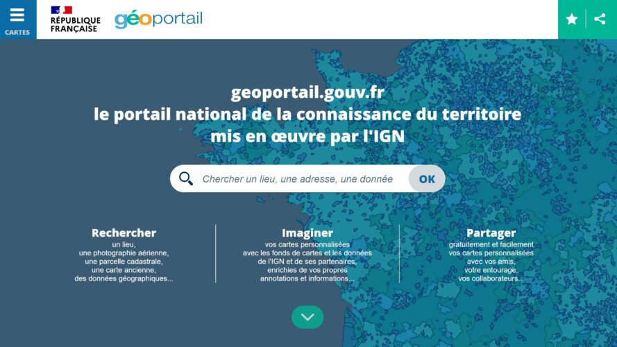
Naviguer sur Géoportail peut parfois ressembler à explorer une carte au trésor numérique. Mais que faire si vous perdez le nord, littéralement ? Pour les passionnés de cartographie ou les amateurs de randonnée, savoir orienter une carte en un clic est essentiel. Pourtant, cette fonctionnalité simple reste méconnue de beaucoup.
Avec ses outils puissants et intuitifs, Géoportail offre bien plus qu’un simple affichage de cartes. Mais pour tirer pleinement parti de ses fonctionnalités, encore faut-il savoir où chercher. Découvrez comment afficher le nord sur Géoportail et transformez votre expérience de navigation en ligne.
Qu’est-ce Que Géoportail ?
Géoportail est une plateforme de cartographie en ligne développée par l’Institut national de l’information géographique et forestière (IGN). Elle offre un accès gratuit à une vaste collection de données géographiques et cartographiques de la France métropolitaine et des territoires d’outre-mer.
Les utilisateurs consultent différentes couches cartographiques, comme les cartes topographiques, les photographies aériennes ou les cartes cadastrales. Chaque carte propose une précision adaptée aux besoins professionnels ou personnels, comme la planification d’activités ou l’exploration du territoire.
Géoportail utilise une interface intuitive, permettant de rechercher des lieux, d’ajouter des annotations ou d’effectuer des mesures. Ces fonctions facilitent l’interprétation des données géographiques et soutiennent des usages variés dans l’éducation, le tourisme ou l’urbanisme.
Importance De Localiser Le Nord Sur Géoportail
Localiser le nord sur Géoportail permet une orientation correcte sur la carte. Sans cette information, l’interprétation des données géographiques devient imprécise, en particulier pour les utilisateurs analysant des zones spécifiques, comme en urbanisme ou en randonnée.
Comprendre la position du nord facilite la cohérence entre la carte numérique et la réalité du terrain. Cette étape est essentielle pour aligner les trajectoires et calculer des distances, garantissant des résultats fiables dans des projets professionnels ou récréatifs.
L’affichage du nord est également critique pour superposer plusieurs couches cartographiques. Les utilisateurs travaillant avec des cartes topographiques, des parcelles cadastrales ou des photographies aériennes bénéficient d’une vision harmonisée, indispensable pour des études précises ou des activités comme l’exploration et la planification.
Ainsi, l’accès à cette fonction sur Géoportail optimise l’exploration des territoires français et des DOM-TOM, enrichissant significativement l’expérience utilisateur.
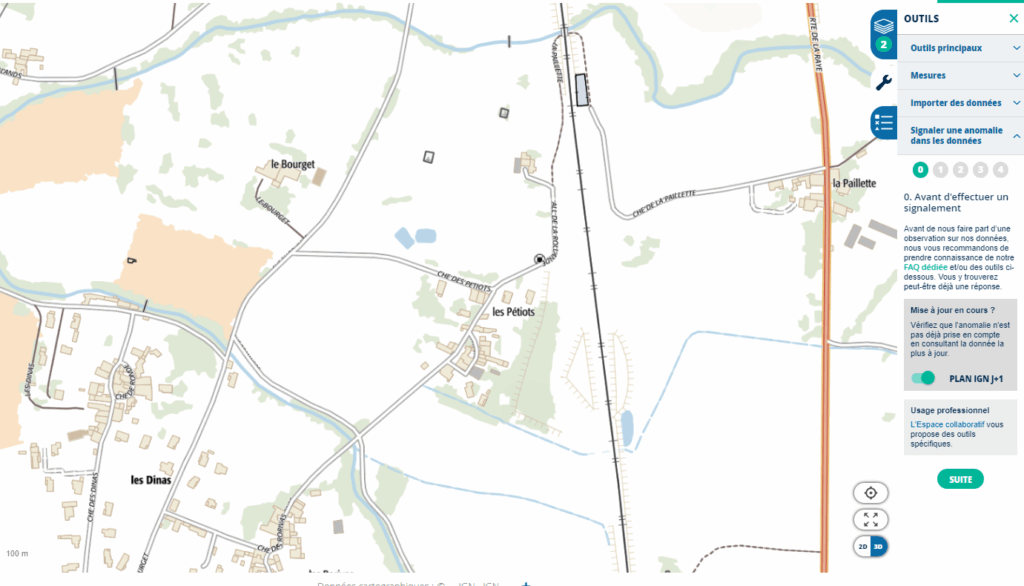
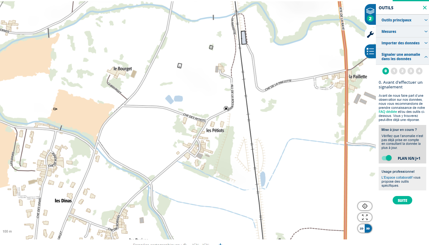
Étapes Pour Faire Apparaître Le Nord Sur Géoportail
L’affichage du nord dans Géoportail améliore la précision lors de l’interprétation des cartes. Suivez les étapes suivantes pour activer cette fonctionnalité.
Connexion À Votre Compte
L’utilisateur accède au site Géoportail en entrant l’URL officielle dans le navigateur : www.geoportail.gouv.fr. Il clique ensuite sur “Se connecter”, situé en haut à droite de l’écran, et entre ses identifiants. Si aucun compte n’existe, un bouton “Créer un compte” permet l’inscription.
Accès Aux Outils De Navigation
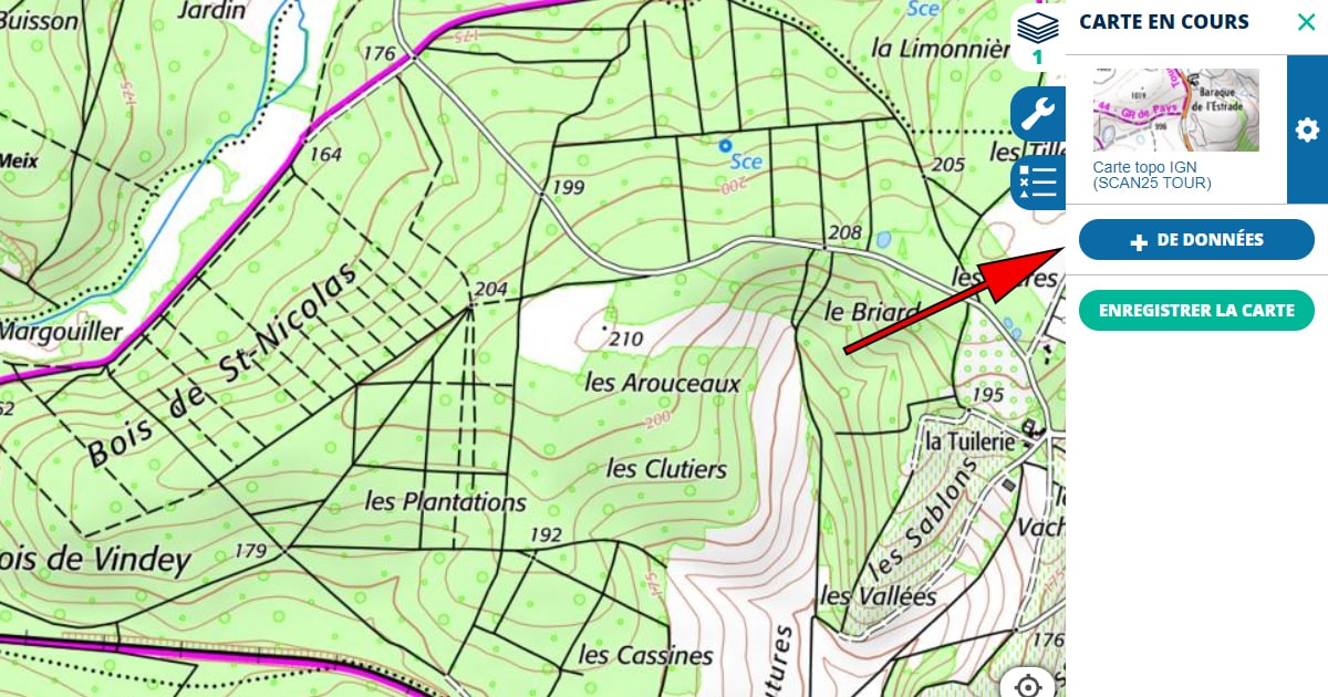
Une fois connecté, l’utilisateur repère le menu principal en haut de l’écran. Il sélectionne l’icône “Outils” ou “Paramètres” selon l’interface. Cette section regroupe des fonctionnalités comme les couches, les mesures et l’orientation.
Activation De La Boussole
Dans le menu des outils, l’utilisateur localise l’option “Boussole” ou “Orientation” et l’active en cliquant sur son symbole. Une flèche ou un indicateur de direction apparaît alors sur la carte, indiquant le nord géographique ou magnétique selon les réglages.
Ajustements Et Calibrage
L’utilisateur vérifie l’orientation en observant les coordonnées affichées sur la carte. Si nécessaire, il ajuste manuellement la position en cliquant et en faisant glisser la carte ou en recentrant la vue depuis l’option “Recentrer”. Les paramètres avancés permettent d’affiner l’affichage, incluant la superposition de plusieurs couches cartographiques.
Avantages D’utiliser La Fonction de Nord Sur Géoportail
La fonction pour afficher le nord sur Géoportail offre des bénéfices pratiques pour une utilisation efficace des cartes en ligne. Elle simplifie l’analyse et améliore la précision dans divers contextes.
Orientation Améliorée
L’affichage du nord sur Géoportail garantit que la carte est alignée correctement avec la réalité géographique. Cette précision est particulièrement utile pour comprendre la position des lieux par rapport à des repères connus. Par exemple, les randonneurs peuvent planifier leurs itinéraires en évitant les erreurs d’orientation. Les urbanistes, en revanche, s’assurent que les cartes respectent les référentiels spatiaux précis lors de la superposition des couches cartographiques.
Navigation Plus Précise
La fonction améliore la navigation pour les utilisateurs analysant des points spécifiques. Elle facilite l’identification des distances et directions exactes entre deux lieux. Par exemple, les touristes explorant des régions nouvelles peuvent suivre des trajets optimaux. Les professionnels travaillant avec des données géographiques complexes, comme les agriculteurs ou les géomètres, bénéficient également de ces ajustements fiables, qui réduisent les erreurs lors de la prise de décision.
Astuces Et Conseils Pratiques
Utiliser la fonction de recherche
Sur Géoportail, la barre de recherche simplifie l’accès à des lieux spécifiques. En saisissant un toponyme ou une adresse précise, les utilisateurs accèdent rapidement à la zone d’intérêt. Par exemple, la recherche de “Mont-Blanc” affiche automatiquement cette région sur la carte.
Activer la boussole pour le nord
Pour afficher le nord, l’option “Boussole” doit être activée dans le menu des outils. Une flèche rouge indiquant le nord apparaît alors sur la carte. Cet outil reste visible même lorsque la carte est déplacée ou agrandie, garantissant une orientation constante.
Personnaliser l’affichage des couches cartographiques
Géoportail propose une superposition de couches comme les cartes IGN, cadastres et orthophotos. L’utilisateur peut régler la transparence pour mieux analyser les données. Par exemple, combiner une carte topographique avec des images aériennes offre une vision plus complète d’une zone.
Sauvegarder des positions stratégiques
En créant un compte sur Géoportail, les utilisateurs peuvent enregistrer des points sur la carte. Ces positions enregistrées permettent un accès rapide à des lieux récurrents.
Consulter les coordonnées précises
L’option “Coordonnées” située dans le menu outils montre la latitude et la longitude exactes du lieu pointé. Les professionnels trouvent cette fonctionnalité précieuse pour des projets nécessitant une précision accrue.
Utiliser les raccourcis clavier efficaces
Plusieurs raccourcis clavier optimisent l’exploration. Par exemple, “Ctrl + flèches directionnelles” déplace la carte, et “Ctrl + molette de la souris” ajuste le zoom. Ces gestes réduisent le temps de navigation.
Télécharger les données cartographiques importantes
Géoportail offre une option de téléchargement pour des cartes ou couches spécifiques. Les utilisateurs peuvent ainsi travailler hors ligne sur des projets nécessitant une consultation locale des données.
Conclusion
Maîtriser l’affichage du nord sur Géoportail transforme l’exploration cartographique en une expérience précise et efficace. Cette fonctionnalité, souvent sous-estimée, joue un rôle clé dans l’orientation et l’analyse des données géographiques. En exploitant pleinement les outils offerts par la plateforme, les utilisateurs, qu’ils soient amateurs ou professionnels, peuvent optimiser leurs projets tout en minimisant les erreurs. Géoportail ne se limite pas à une simple carte; il devient un véritable allié pour naviguer, planifier et explorer avec confiance.
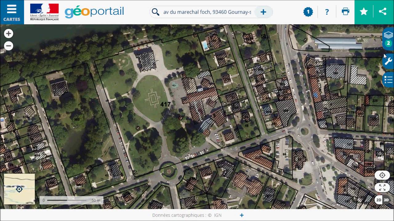
Explorer un sentier méconnu, planifier une randonnée ou simplement admirer les détails d’un territoire… Les cartes IGN sont des alliées précieuses. Mais que faire lorsqu’on souhaite une version papier pour l’emporter avec soi ? Grâce à Géoportail, il est désormais possible d’imprimer facilement des cartes personnalisées, adaptées à vos besoins.
Cette plateforme intuitive offre bien plus qu’une simple consultation en ligne. Elle permet de sélectionner, personnaliser et imprimer des cartes détaillées en quelques clics. Découvrez comment utiliser cet outil pour créer une carte IGN sur mesure, prête à vous accompagner dans toutes vos aventures.
Qu’est-Ce Que Géoportail Et Les Cartes IGN ?
Géoportail est une plateforme en ligne développée par l’Institut national de l’information géographique et forestière (IGN). Elle offre un accès gratuit à des données géographiques variées. Les utilisateurs peuvent y consulter des cartes topographiques précises, des images satellites et d’autres couches d’informations géospatiales.
Les cartes IGN sont des documents de référence pour représenter le territoire français avec une grande précision. Elles indiquent des éléments tels que les courbes de niveau, les chemins de randonnée, les rivières et les limites administratives. Ces cartes sont particulièrement utiles pour les randonneurs, les géographes et les amateurs d’activités de plein air cherchant des informations fiables et détaillées.
Géoportail permet d’accéder à ces cartes en ligne, avec des outils pour zoomer, superposer des données et personnaliser l’affichage. Cela en fait une ressource puissante pour explorer et planifier des trajets en fonction des besoins spécifiques de chacun. Les utilisateurs peuvent également imprimer des extraits de cartes directement depuis la plateforme.
Pourquoi Imprimer Une Carte IGN Sur Géoportail ?
Imprimer une carte IGN depuis Géoportail permet d’obtenir un support papier fiable pour explorer des zones sans réseau mobile. Les cartes IGN offrent une précision idéale pour les activités de plein air comme la randonnée, le camping ou le vélo.
La version imprimée facilite la navigation lors des longues sorties en pleine nature. Les informations comme les courbes de niveau, les sentiers et les repères topographiques restent toujours disponibles, même en l’absence de signal GPS.
Les zones rurales ou montagneuses, souvent mal couvertes par les réseaux numériques, nécessitent des alternatives comme les cartes papier. En personnalisant l’extrait sur Géoportail, l’utilisateur peut se concentrer sur une zone spécifique, utile pour les itinéraires hors des chemins balisés.
L’ajout de couches, comme les zones protégées ou les points d’intérêt, enrichit les cartes imprimées. Cela aide à combiner les détails pertinents et à optimiser la préparation de l’itinéraire avant le départ.
Étapes Pour Imprimer Une Carte IGN Sur Géoportail
Imprimer une carte IGN sur Géoportail demande quelques étapes simples. La plateforme propose des outils intuitifs pour configurer et personnaliser l’affichage avant impression.
Accéder Au Site De Géoportail
L’utilisateur doit ouvrir un navigateur et visiter www.geoportail.gouv.fr. La page d’accueil affiche une carte interactive avec diverses options d’exploration.
Rechercher La Zone à Imprimer
Il utilise la barre de recherche en haut de la page pour entrer une localité, un code postal ou des coordonnées GPS. Une fois le lieu localisé, il peut utiliser la souris ou les boutons de zoom pour ajuster l’échelle et centrer la zone souhaitée.
Configurer Les Options D’Affichage
Il clique sur l’onglet “Cartes” ou “Données” pour sélectionner les couches disponibles, telles que les cartes topographiques, les images satellites ou les informations sur les sentiers. Il ajuste ensuite les niveaux de transparence ou d’échelle pour personnaliser la vue.
Télécharger Et Imprimer La Carte
Une fois les réglages effectués, il sélectionne l’icône d’imprimante ou l’option “Exporter au format PDF” dans le menu. Après avoir téléchargé le fichier PDF, il vérifie l’aperçu, puis utilise une imprimante pour produire la carte en qualité optimale.
Conseils Pour Une Impression Optimale
Utiliser une résolution élevée
Sélectionner une qualité d’impression de 300 DPI ou supérieure améliore la lisibilité des cartes. Une résolution élevée garantit des détails précis, comme les courbes de niveau et les points d’intérêt.
Choisir le format papier adapté
Imprimer sur un format A4 ou A3 est recommandé selon l’étendue de la zone sélectionnée. Un format A3 offre une vue plus étendue, utile pour les longues randonnées.
Vérifier les marges d’impression
Ajuster les marges dans les paramètres d’impression évite de couper des informations importantes sur les bords. Prévoir un cadre blanc autour de la carte peut aussi faciliter son manipulation.
Opter pour un papier résistant
Utiliser du papier épais ou imperméable réduit les risques de déchirures ou de dégâts causés par l’humidité. Ce type de support est adapté aux environnements extérieurs.
Préparer un aperçu de la carte
Consulter un aperçu PDF avant l’impression permet d’identifier d’éventuelles erreurs. Cela garantit une carte conforme aux préférences de l’utilisateur.
Configurer les paramètres de couleurs
Imprimer en couleurs restitue fidèlement les détails de la carte. Si l’imprimante ne supporte que le noir et blanc, vérifier le contraste et les niveaux de gris est essentiel pour une bonne lecture.
Inclure une échelle et une légende
S’assurer que l’échelle et la légende sont visibles sur la carte aide à interpréter les distances et les symboles. Ces éléments sont indispensables pour s’orienter.
Superposer les couches utiles
Activer les couches d’informations pertinentes, comme les sentiers, les points d’eau, ou les zones protégées, enrichit la carte imprimée en fonction des besoins spécifiques.
Alternatives À Considérer
1. Autres plateformes cartographiques
Il existe des alternatives à Géoportail pour imprimer des cartes IGN. Des outils comme Google Earth ou OpenStreetMap permettent d’accéder à des données géographiques. Tous n’incluent cependant pas les mêmes détails topographiques que Géoportail.
2. Cartes papier IGN disponibles en magasin
Les cartes IGN traditionnelles sont disponibles dans des librairies, des boutiques sportives ou sur le site officiel IGN. Elles sont précises, couvrent tout le territoire français et ne nécessitent pas d’impression.
3. Applications mobiles spécialisées
Des applications comme Visorando ou Iphigénie donnent accès à des cartes IGN avec des options de téléchargement pour usage hors-ligne. Avec un appareil compatible, elles remplacent les cartes imprimées.
4. Logiciels de cartographie
Des logiciels comme QGIS permettent aux utilisateurs avancés de personnaliser des cartes. Ces outils prennent en charge des formats variés et offrent des fonctionnalités de mise en page précises avant impression.
5. Services en ligne
Certains sites, comme Cartes-Express, proposent l’impression de cartes personnalisées. Ces services incluent parfois des supports imperméables ou des ajouts spécifiques comme des tracés de parcours.
Conclusion
Imprimer une carte IGN sur Géoportail reste une solution pratique et accessible pour préparer des aventures en plein air. Cette plateforme offre une personnalisation poussée et des cartes détaillées adaptées aux besoins des utilisateurs, garantissant une navigation fiable même sans réseau mobile.
Avec des conseils simples pour optimiser l’impression et des alternatives intéressantes pour explorer d’autres options, chacun peut trouver l’outil idéal pour ses projets. Que ce soit pour une randonnée, du camping ou une sortie à vélo, une carte bien préparée est un atout indispensable.
Explorer le monde sans bouger de chez soi, c’est désormais possible grâce au site Géoportail. Ce trésor numérique, souvent méconnu du grand public, regorge d’outils fascinants pour visualiser et comprendre les territoires sous un nouvel angle. Que vous soyez randonneur passionné, urbaniste ou simplement curieux de votre environnement, Géoportail promet une expérience immersive et riche en découvertes.
Avec une interface intuitive et des fonctionnalités variées, ce site va bien au-delà d’une simple carte en ligne. Il offre une plongée dans des données géographiques détaillées, des vues aériennes spectaculaires et des informations précieuses pour explorer les moindres recoins du territoire français. Mais quelles sont exactement ces fonctionnalités qui le rendent si unique ?
Présentation Du Géoportail
Géoportail est une plateforme en ligne développée par l’Institut national de l’information géographique et forestière (IGN). Elle propose des données cartographiques, des photographies aériennes, et des informations géographiques sur le territoire français. Les utilisateurs accèdent à des cartes interactives ainsi qu’à des outils de mesure et de comparaison.
Les principaux objectifs du site incluent l’accès gratuit à des ressources géographiques détaillées et la promotion d’une meilleure compréhension du paysage français. Que ce soit pour planifier des randonnées, étudier des zones urbaines ou découvrir des données historiques, Géoportail offre une large gamme de fonctionnalités adaptées à divers besoins.
L’interface intuitive facilite la recherche et l’affichage des informations. Les utilisateurs peuvent visualiser des cartes en 2D et 3D, régler le niveau de transparence des couches, et consulter des données de différentes thématiques, comme l’occupation des sols ou les limites administratives.
Navigation Et Recherche
Géoportail offre des outils puissants pour explorer et analyser les données géographiques du territoire français. Chaque utilisateur peut profiter des fonctionnalités optimisées pour la navigation et la recherche.
Cartes Interactives
Les cartes interactives de Géoportail permettent de consulter divers fonds de carte adaptés aux besoins. Les utilisateurs peuvent afficher des cartes topographiques, des images satellites ou des cartes historiques. Des couches supplémentaires, comme les limites administratives ou les zones protégées, peuvent être activées pour enrichir l’affichage. La fonction d’échelle dynamique ajuste automatiquement les détails visibles selon le niveau de zoom, offrant une précision accrue.
Outils De Recherche Par Localisation
Les outils de recherche facilitent l’accès à des lieux précis sur les cartes. Un moteur de recherche intégré permet de localiser une adresse, une commune, ou des coordonnées géographiques. La recherche avancée propose des filtres pour cibler des points d’intérêt spécifiques, comme des bâtiments publics ou des sites touristiques. Une fonctionnalité de géocodage inverse permet d’identifier une localisation exacte à partir d’un point marqué sur la carte.
Visualisation Des Données
Géoportail permet d’afficher et d’explorer des données géographiques avec une grande précision. Les outils de visualisation aident à comprendre le territoire français à travers différentes perspectives.
Superposition Des Couches De Données
L’utilisateur peut activer plusieurs couches d’informations pour enrichir l’affichage. Parmi les options disponibles, on trouve les limites administratives, les réseaux hydrographiques et les infrastructures de transport. Chaque couche apporte des détails spécifiques, comme les zones protégées ou les types d’occupation des sols. La fonction de transparence ajuste la visibilité des couches, facilitant l’analyse des données combinées.
Imagerie Aérienne Et Satellitaire
Géoportail propose des images aériennes et satellitaires actualisées, offrant une vue détaillée du territoire. Ces images incluent des vues haute résolution provenant de satellites comme Sentinel-2 ou Spot. Les photographies historiques permettent de comparer les évolutions paysagères dans le temps. Cette fonctionnalité est utile pour ceux qui analysent les changements environnementaux ou les projets d’aménagement.
Outils Pour Les Utilisateurs
Géoportail propose plusieurs outils pratiques pour examiner, manipuler et exporter des données géographiques selon les besoins des utilisateurs.
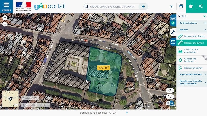
Mesure De Distances Et Surfaces
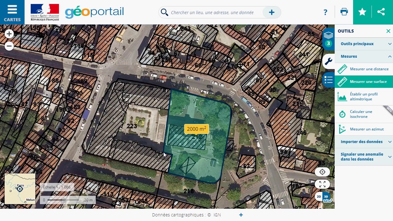
Les utilisateurs peuvent mesurer des distances linéaires et des surfaces directement sur les cartes interactives. L’outil permet de tracer des segments, des polygones ou des cercles pour obtenir des résultats précis. Par exemple, il est possible de calculer la taille d’un champ ou la longueur d’un sentier. Ces mesures sont visibles en mètres ou en kilomètres pour les distances, et en mètres carrés ou hectares pour les surfaces, selon l’échelle sélectionnée.
Impression Et Téléchargement De Cartes
Le service offre une fonctionnalité pour imprimer ou télécharger des cartes personnalisées. L’utilisateur peut choisir l’échelle, la zone à couvrir et les couches d’information visibles. Cela permet de générer des fichiers au format PDF ou des images pour une utilisation hors ligne ou des présentations. Par exemple, un plan détaillé d’une région peut être exporté avec des informations spécifiques comme les réseaux routiers ou les zones boisées.
Fonctionnalités Avancées
Analyse 3D Du Territoire
Géoportail permet une visualisation en trois dimensions des données géographiques. Les utilisateurs peuvent examiner des paysages, des reliefs et des constructions en activant le mode 3D. Cet outil offre une perspective réaliste et interactive sur le territoire français, simplifiant l’exploration de surfaces complexes. Des fonctions comme l’orientation de la caméra ou le zoom améliorent l’interprétation des détails topographiques.
Accès Aux Données Géographiques
La plateforme fournit un accès étendu à des jeux de données géographiques précis. Les utilisateurs peuvent consulter des informations sur les réseaux routiers, les cours d’eau ou les zones protégées via des cartes thématiques. Géoportail propose également l’intégration de données externes, permettant d’ajouter des fichiers au format standard (comme WMS ou KML) pour enrichir les projets. Ce service offre une mise à jour régulière des données, assurant leur exactitude.
Conclusion
Géoportail s’impose comme une ressource incontournable pour l’exploration et l’analyse des données géographiques en France. Son interface intuitive, ses outils performants et ses cartes détaillées répondent aux besoins d’un large éventail d’utilisateurs, qu’ils soient professionnels ou amateurs.
Grâce à ses fonctionnalités avancées et à la richesse des informations qu’il propose, Géoportail facilite la compréhension des territoires et l’accès à des données précises, tout en encourageant une utilisation pratique et personnalisée. Cette plateforme continue d’évoluer pour offrir une expérience toujours plus enrichissante.
Explorer les détails d’un territoire n’a jamais été aussi simple qu’avec Géoportail. Imaginez pouvoir visualiser chaque parcelle de terrain, que ce soit pour un projet immobilier, une randonnée ou simplement par curiosité. Cet outil numérique, souvent sous-estimé, offre une mine d’informations précieuses à portée de clic.
Mais comment s’y retrouver parmi toutes ces fonctionnalités ? Découvrir les parcelles, comprendre leurs limites et accéder aux données associées peut sembler complexe au premier abord. Pourtant, avec quelques astuces, Géoportail devient un allié incontournable pour naviguer dans le paysage géographique français.
Qu’est-Ce Que Géoportail ?
Géoportail est une plateforme en ligne développée par l’Institut national de l’information géographique et forestière (IGN). Il offre des cartes et des données géographiques variées sur le territoire français. Ce service est accessible gratuitement depuis un navigateur internet.
Les utilisateurs peuvent consulter des plans cadastraux, explorer des cartes topographiques ou visualiser des données satellitaires. Ces informations sont utiles pour des projets liés à l’aménagement du territoire, l’immobilier ou les activités de plein air.
La plateforme regroupe également des outils d’analyse, comme la mesure de distances ou de surfaces. Ces fonctionnalités permettent d’examiner précisément chaque parcelle de terrain et de répondre à des besoins spécifiques.
Pourquoi Utiliser Géoportail Pour Voir Les Parcelles ?
Accès à des données détaillées
Géoportail fournit des informations précises sur chaque parcelle, incluant les limites cadastrales, la superficie et l’usage du sol. Ces données permettent d’obtenir une vue claire et compréhensible des propriétés foncières, essentielle pour des projets urbains ou agricoles.
Outil gratuit et accessible
Disponible gratuitement, Géoportail offre une plateforme accessible en ligne. Aucun logiciel spécifique ni abonnement n’est nécessaire, ce qui en fait une solution économique pour les utilisateurs.
Multi-couches d’informations
Les utilisateurs peuvent superposer plusieurs couches, comme les cartes cadastrales, orthophotos et cartes IGN. Cette fonctionnalité aide à visualiser les parcelles dans leur contexte géographique, en tenant compte des caractéristiques des environs.
Mesure et analyse
Avec les outils intégrés, il est possible de mesurer les distances, calculer les surfaces et examiner des détails géographiques. Ces options conviennent pour des analyses approfondies, telles que les évaluations foncières ou les études d’aménagement.
Documentation officielle
Les plans cadastraux affichés proviennent de sources officielles, garantissant la fiabilité des informations. Ils coïncident avec les données fournies par le cadastre officiel, un atout pour des démarches administratives ou juridiques.
Compatibilité avec divers usages
Géoportail est utilisé dans des secteurs variés, notamment l’immobilier, l’agriculture et l’environnement. Il répond aux besoins des professionnels et particuliers cherchant une visualisation fiable et précise des parcelles.
Étapes Pour Accéder Aux Parcelles Sur Géoportail
Visualiser des parcelles sur Géoportail nécessite de suivre des étapes simples. Ces démarches permettent d’exploiter efficacement les fonctionnalités disponibles.
Création D’un Compte
La création d’un compte sur Géoportail est facultative mais améliore l’expérience utilisateur. L’utilisateur accède au formulaire d’inscription depuis l’onglet “Mon compte”. Il remplit les champs requis, comme le nom, l’email et le mot de passe, puis valide l’inscription par un email de confirmation. Un compte permet de sauvegarder des recherches et personnaliser l’affichage.
Recherche Par Adresse Ou Coordonnées
Pour localiser une parcelle, l’utilisateur démarre depuis la barre de recherche en haut de la page. Il entre une adresse précise ou des coordonnées GPS. Géoportail affiche alors la zone correspondante sur la carte. Les boutons de zoom facilitent l’exploration de la région sélectionnée.
Affichage Des Parcelles Détailées
Les parcelles s’affichent en activant la couche cadastrale. Via le menu de gauche, l’utilisateur ouvre “Cartes” et coche “Cadastral”. Les contours des parcelles apparaissent immédiatement sur la carte. En cliquant sur une parcelle, des informations comme la référence cadastrale et les dimensions s’affichent dans une fenêtre latérale.
Fonctionnalités Supplémentaires De Géoportail
Géoportail comprend des outils avancés permettant d’améliorer l’expérience de visualisation et d’analyse des parcelles. Ces fonctionnalités rendent la plateforme polyvalente et utile pour un large éventail d’utilisations.
Options De Superposition De Cartes
Les utilisateurs peuvent combiner plusieurs couches cartographiques pour une meilleure analyse. Ces couches incluent des plans cadastraux, des cartes topographiques et des orthophotos. En superposant une couche sur une autre, il devient possible d’examiner les limites des parcelles en relation avec les caractéristiques géographiques adjacentes comme les cours d’eau ou les voies de transport.
L’affichage des couches peut être ajusté grâce à des réglages de transparence. Cela permet d’associer des données complémentaires sans masquer les informations essentielles. Par exemple, on peut superposer une carte du zonage agricole avec des orthophotos pour identifier les cultures sur une parcelle spécifique.
Mesures Et Dessins Sur La Carte
Géoportail propose des outils pour mesurer et annoter directement sur les cartes. Les utilisateurs peuvent calculer les distances avec précision entre deux points ou mesurer la superficie d’une parcelle sélectionnée. Ces outils sont utiles pour des projets de délimitation foncière ou d’aménagement.
Des outils de dessin permettent également de tracer des limites, des chemins ou des zones d’intérêt. Ces annotations restent visibles tant que l’utilisateur navigue dans la section active, facilitant le repérage ou le partage d’informations. Par exemple, un professionnel de l’immobilier peut prévisualiser un périmètre pour un projet de construction.
Conseils Pratiques Pour Une Utilisation Optimale
Activer et gérer les couches cartographiques
Pour voir les parcelles sur Géoportail, l’utilisateur active les couches pertinentes comme “Cadastre” ou “Orthophotographies”. Il ajuste la transparence des couches afin de combiner plusieurs types de données et d’obtenir une vue claire.
Utiliser la barre de recherche efficacement
Les recherches par adresse ou coordonnées GPS permettent de localiser rapidement une parcelle. Saisir une adresse complète ou des données géographiques précises optimise les résultats.
Exploiter les outils de mesure
Les outils intégrés mesurent les distances et les surfaces directement sur la carte. Ces fonctionnalités précises sont utiles pour évaluer des terrains ou des projets de construction.
Créer un compte utilisateur
Créer un compte facilite l’enregistrement des recherches et la gestion des cartes personnalisées. Les utilisateurs enregistrent leurs préférences pour un accès direct et répété.
Télécharger les données nécessaires
L’option de téléchargement permet d’exporter des cartes ou des informations cadastrales spécifiques pour un usage hors ligne ou des analyses professionnelles.
Conclusion
Géoportail se distingue comme un outil incontournable pour explorer et analyser les parcelles en France. Grâce à ses multiples fonctionnalités et sa simplicité d’accès, il répond aux besoins variés des particuliers et des professionnels.
Qu’il s’agisse de projets immobiliers, agricoles ou environnementaux, cette plateforme offre une précision et une fiabilité remarquables. Avec un peu de pratique, chacun peut exploiter tout son potentiel pour naviguer efficacement dans le paysage géographique.
Saviez-vous que l’altitude peut révéler bien plus que de simples chiffres sur une carte ? Que vous soyez randonneur passionné, géographe curieux ou simplement amateur de découvertes, comprendre les variations d’altitude peut transformer votre perception des paysages. Géoportail, cet outil incontournable, ne se limite pas à afficher des cartes : il offre une mine d’informations précieuses, dont l’altitude.
Mais comment accéder facilement à ces données ? Beaucoup ignorent les fonctionnalités spécifiques qui rendent Géoportail si puissant. Dans cet article, découvrez une méthode simple et efficace pour visualiser l’altitude et enrichir votre exploration du territoire. Une fois maîtrisée, cette astuce pourrait bien changer votre manière d’interagir avec les cartes.
Qu’est-ce Que Géoportail ?
Géoportail est une plateforme en ligne créée par l’Institut national de l’information géographique et forestière (IGN). Elle permet d’accéder à une vaste collection de données géographiques concernant le territoire français. Les utilisateurs peuvent explorer des cartes interactives, des images satellites, et des reliefs détaillés.
L’un de ses principaux atouts est l’affichage de données précises sur l’altitude. Géoportail indique les altitudes des terrains, facilitant l’analyse topographique. En plus des cartes classiques, il intègre des outils avancés pour mesurer des distances, visualiser des profils altimétriques, et examiner des zones spécifiques.
Cette plateforme est consultable sur n’importe quel appareil disposant d’une connexion internet. Les fonctionnalités, comme l’affichage 3D et la superposition de couches thématiques, enrichissent l’expérience des utilisateurs. Géoportail est ainsi une ressource incontournable pour des activités comme la randonnée, l’urbanisme, ou la recherche scientifique.
Pourquoi Utiliser Géoportail Pour Voir L’altitude ?
Géoportail fournit des informations altimétriques précises grâce à des technologies et des données officielles de l’IGN. Il permet de localiser rapidement la hauteur d’un point particulier en France.
Fiabilité des données
Les informations sur l’altitude de Géoportail proviennent de l’Institut national de l’information géographique et forestière. Ces données bénéficient d’une mise à jour régulière et d’une précision garantie.
Cartes interactives et outils avancés
Géoportail propose des options pour visualiser des profils altimétriques, mesurer des dénivelés ou afficher des courbes de niveau. Ces outils simplifient l’exploration topographique.
Accessibilité multiplateforme
Le site et l’application permettent un accès pratique, que ce soit sur ordinateur, tablette ou smartphone, via une connexion Internet.
Visualisation en 3D
L’option 3D améliore la perception des reliefs en superposant des données altimétriques sur des modèles réalistes. Ce mode est particulièrement utile pour évaluer des terrains complexes.
Utilisation pour activités variées
Que ce soit pour planifier une randonnée, développer un projet urbain ou effectuer une analyse géographique, les informations d’altitude disponibles enrichissent la qualité des études et des préparations.
Géoportail combine précision, accessibilité et outils puissants pour répondre efficacement à divers besoins liés à l’altitude.
Étapes Pour Voir L’altitude Sur Géoportail
L’accès aux données d’altitude sur Géoportail se fait en quelques étapes simples. L’utilisateur peut rapidement consulter des informations précises grâce aux outils intégrés à la plateforme.
Accéder Au Site De Géoportail
Pour commencer, ouvrir un navigateur web et accéder au site officiel Géoportail. Sur la page d’accueil, plusieurs options se présentent, comme les cartes et les outils de recherche. Aucune inscription préalable n’est requise pour consulter les données générales.
Utiliser Les Différents Outils De Visualisation
Après l’accès au site, utiliser la barre de recherche pour localiser une zone précise en entrant une adresse ou un lieu. Une fois la carte affichée, cliquer sur l’icône des calques à droite pour activer les couches thématiques. Choisir une carte spécifique comme “Cartes IGN classiques” ou “Modèle Numérique de Terrain” pour afficher les reliefs.
Activer La Fonction Altitude
Pour afficher l’altitude en un point précis, cliquer sur l’outil “Infos sur la carte”, représenté par une icône “i”. Puis, sélectionner un emplacement sur la carte. La plateforme affiche immédiatement l’altitude exacte en mètres dans une fenêtre contextuelle. Pour des analyses plus avancées, activer le module “Calcul de profils altimétriques” depuis le menu des outils.
Avantages De Consulter L’altitude Sur Géoportail
La consultation de l’altitude sur Géoportail présente plusieurs bénéfices pour les utilisateurs. Ces avantages incluent la précision des données et une interface accessible et facile à utiliser.
Précision Des Données
Géoportail fournit des données altimétriques fiables, mises à jour par l’Institut national de l’information géographique et forestière (IGN). Les informations intègrent une précision adaptée aux analyses géographiques détaillées. Les courbes de niveau et mesures de dénivelé affichent une précision souvent inférieure à 1 mètre. Par exemple, les profils altimétriques générés aident les randonneurs à planifier leurs itinéraires en calculant les inclinaisons exactes.
Accessibilité Et Simplicité D’utilisation
Géoportail fonctionne sur tous les appareils connectés à Internet, sans installation de logiciel supplémentaire. Son interface intuitive permet d’activer rapidement des couches thématiques, comme le relief ou les images satellites. Les outils tels que “Infos sur la carte” ou “Calcul de profils altimétriques” simplifient l’accès aux données d’altitude. Par exemple, en cliquant sur un point d’une région, l’utilisateur obtient instantanément l’altitude précise.
Limites Et Alternatives À Géoportail
Limites De Géoportail
Géoportail offre des données altimétriques précises, mais il présente certaines limites. La couverture est limitée au territoire français, excluant les régions hors de France. Les grandes zones en dehors de l’Hexagone nécessitent l’utilisation d’autres plateformes. Les fonctionnalités avancées comme la création de profils altimétriques nécessitent une connexion stable, ce qui peut poser un problème en déplacement ou en montagne. L’expérience utilisateur peut être réduite sur des appareils avec des écrans petits, comme les smartphones, en raison d’une interface moins adaptée au format compact.
Alternatives Disponibles
Lorsqu’il est nécessaire d’étudier l’altitude hors de France ou sans connexion Internet, d’autres solutions existent.
Google Earth
Fournit des données globales, consultables en mode hors-ligne après pré-téléchargement. L’outil permet aussi une vue 3D des reliefs.
OpenTopoMap
Offrant des cartes topographiques gratuites, il s’adresse aux utilisateurs recherchant des informations basées sur OpenStreetMap avec altitudes ajoutées.
QGIS
Approprié pour des analyses avancées, ce logiciel open-source propose des options de visualisation et traitement des données terrain détaillées. Il demande des compétences en SIG (systèmes d’information géographique).
ViewRanger
Spécifiquement utile pour les randonneurs grâce à ses cartes altimétriques et son suivi GPS, il fonctionne aussi hors-ligne après la sauvegarde.
Ces solutions complètent Géoportail et élargissent les options pour les utilisateurs en quête de flexibilité géographique ou fonctionnelle.
Conclusion
Géoportail s’impose comme un outil incontournable pour explorer l’altitude avec précision et simplicité. Grâce à ses fonctionnalités avancées et ses données fiables, il répond aux besoins variés des amateurs de géographie, des randonneurs et des professionnels.
Bien que limité au territoire français, il offre une expérience enrichissante pour analyser les reliefs et planifier des projets ou activités. Pour ceux cherchant davantage de flexibilité, les alternatives mentionnées complètent parfaitement ses fonctionnalités.
Avec Géoportail, la compréhension des paysages et des altitudes devient accessible à tous, transformant ainsi l’exploration géographique en une expérience fluide et immersive.
Visualiser les pentes d’un terrain peut sembler complexe, mais avec Géoportail, tout devient étonnamment accessible. Imaginez planifier une randonnée ou un projet d’aménagement et avoir à portée de main des données précises sur les inclinaisons du sol. Cet outil numérique, souvent sous-estimé, offre bien plus que des cartes : il dévoile les reliefs comme jamais auparavant.
Dans cet article, découvrez comment utiliser Géoportail pour explorer les pentes avec précision. Que vous soyez amateur de plein air ou professionnel en quête d’informations topographiques, ces astuces vous permettront d’exploiter tout le potentiel de cette plateforme intuitive.
Qu’est-Ce Que Géoportail ?
Géoportail est une plateforme en ligne développée par l’Institut national de l’information géographique et forestière (IGN). Il permet d’accéder à des cartes et des données géographiques précises couvrant le territoire français.
L’interface offre diverses couches d’informations, comme les cartes topographiques, les images satellites, et les données altimétriques. Ces fonctionnalités sont utiles pour analyser le relief, identifier les pentes, et préparer des projets nécessitant une connaissance détaillée du terrain.
Géoportail inclut des outils interactifs permettant de zoomer, de mesurer des distances, et de consulter le profil altimétrique d’un itinéraire. Les données sont mises à jour régulièrement pour garantir leur exactitude.
Pourquoi Utiliser Géoportail Pour Voir Les Pentes ?
Géoportail offre des données altimétriques précises pour examiner les pentes. Les cartes topographiques et les profils altimétriques permettent d’analyser les niveaux d’inclinaison des terrains, utiles en randonnée et en construction.
L’interface inclut des outils interactifs comme la mesure des distances et le suivi des variations altimétriques. Ces fonctions simplifient la visualisation des reliefs et facilitent les prises de décision.
Les couches disponibles, comme les données lidar ou les images satellites, renforcent l’exactitude des informations. Ces données soutiennent divers projets nécessitant une connaissance fine du terrain.
Les mises à jour régulières garantissent la fiabilité des informations affichées. En conséquence, les utilisateurs peuvent exploiter des données géographiques actuelles et adaptées à leurs besoins.
Étapes Pour Voir Les Pentes Sur Géoportail
Analyser les pentes sur Géoportail repose sur une utilisation méthodique de ses outils. Les étapes ci-dessous expliquent comment tirer profit de ses fonctionnalités pour visualiser les inclinaisons d’un terrain.
Accéder Au Site De Géoportail
L’utilisateur ouvre un navigateur web et entre l’adresse officielle de Géoportail (www.geoportail.gouv.fr). Une fois sur le site, l’interface principale affiche une carte de la France avec des options de navigation à gauche. Aucun compte utilisateur n’est requis pour accéder aux fonctionnalités de base.
Activer L’Option De Visualisation Des Pentes
Dans le panneau des outils, l’utilisateur clique sur l’onglet de gestion des “couches”. Il sélectionne “Cartes & Données” pour explorer les couches disponibles. En choisissant “Altimétrie par pentes”, une couche spécifique s’applique à la carte, illustrant la répartition des inclinaisons en couleurs distinctes. Ces dégradés indiquent les variations d’angles des pentes, simplifiant l’analyse visuelle.
Ajuster Les Paramètres D’Affichage
L’utilisateur ajuste l’échelle de la carte en approchant ou éloignant le zoom selon les besoins. Dans les paramètres liés à l’affichage, il peut modifier l’opacité de la couche d’altimétrie ou superposer d’autres données, comme les images aériennes. Ces ajustements permettent d’obtenir une vue précise et personnalisée du terrain, adaptée à chaque projet.
Astuces Pour Une Meilleure Utilisation
Géoportail offre plusieurs options pour optimiser l’expérience utilisateur lors de l’analyse des pentes. Ces outils permettent d’obtenir des données visuelles et techniques adaptées aux besoins spécifiques.
Personnaliser Les Couleurs Des Pentes
L’option de personnalisation des couleurs aide à différencier les niveaux d’inclinaison. L’utilisateur accède à cette fonctionnalité en ouvrant le menu des couches, sélectionnant “Altimétrie par pentes”, puis ajustant les paramètres dans “Style des pentes”. Il peut attribuer des couleurs distinctes aux catégories d’inclinaison, par exemple le vert pour les pentes faibles et le rouge pour les pentes raides. Ces ajustements offrent une lecture claire et rapide des informations.
Télécharger Les Données De Pentes
Pour travailler hors ligne ou utiliser les données sur d’autres logiciels, Géoportail permet de télécharger les couches altimétriques. En cliquant sur l’onglet “Exporter les données”, l’utilisateur choisit le format souhaité, comme GeoTIFF ou SHP. Ces formats sont compatibles avec de nombreux outils SIG (systèmes d’information géographique). Ils contiennent des informations détaillées sur le relief et les inclinaisons du terrain, idéales pour les études ou les projets d’aménagement.
Avantages Et Applications Pratiques
Planification des activités de plein air
Géoportail aide à préparer des itinéraires pour des randonnées ou cyclotours, en évaluant l’inclinaison des reliefs. Les cartes topographiques et les données altimétriques fournissent des informations détaillées sur la difficulté des terrains. Cela permet d’anticiper des passages complexes, d’ajuster les trajets et de garantir une meilleure sécurité pour les activités en extérieur.
Aide à l’aménagement du territoire
Les données altimétriques de Géoportail facilitent la conception de projets d’aménagement, tels que des routes ou des sentiers. Les couches “Altimétrie” et “Altimétrie par pentes” permettent de visualiser précisément les niveaux d’inclinaison, essentiels pour localiser des zones constructibles ou évaluer des risques d’érosion. Les professionnels s’appuient sur ces outils pour obtenir des mesures précises et réduire les obstacles liés au relief.
Analyse des risques naturels
La visualisation des pentes aide à identifier les zones sujettes aux éboulements, glissements de terrain et crues. Les informations sur l’inclinaison servent à planifier la gestion des zones à risque. Les données de Géoportail, combinées à d’autres analyses géologiques, renforcent la prévention des catastrophes.
Études environnementales
Les couches disponibles dans Géoportail soutiennent les chercheurs et écologistes dans leurs analyses. L’étude des pentes contribue à comprendre la répartition des habitats naturels et des cours d’eau. Ces informations bénéficient à l’aménagement durable du territoire et aux projets de conservation.
Applications pédagogiques
Les enseignants utilisent Géoportail pour illustrer des concepts géographiques liés au relief et à la topographie. Les élèves explorent les pentes et simulent des études pratiques grâce aux outils interactifs de la plateforme. Cela améliore leur compréhension des terrains et des cartes altimétriques.
Conclusion
Géoportail se révèle être un outil incontournable pour explorer et analyser les pentes avec précision. Grâce à ses fonctionnalités interactives et ses données fiables, il répond aussi bien aux besoins des amateurs d’activités de plein air qu’à ceux des professionnels en aménagement ou en recherche.
Avec une interface intuitive et des options de personnalisation avancées, il permet d’obtenir une vision détaillée du terrain. Que ce soit pour planifier une randonnée, concevoir un projet ou approfondir des études géographiques, Géoportail offre des solutions adaptées et efficaces.
Lorsqu’il s’agit d’explorer des cartes interactives ou de plonger dans des données géographiques détaillées, beaucoup connaissent Géoportail en France. Mais qu’en est-il de l’Espagne ? Avec ses paysages variés et son riche patrimoine, ce pays dispose également d’outils numériques puissants pour naviguer dans son territoire.
Pour les amateurs de cartographie ou les professionnels en quête d’informations précises, découvrir l’équivalent espagnol de Géoportail peut ouvrir de nouvelles perspectives. Quels services offrent-ils ? Comment ces plateformes se comparent-elles ? Une plongée dans cet univers révèle des ressources fascinantes pour explorer l’Espagne comme jamais auparavant.
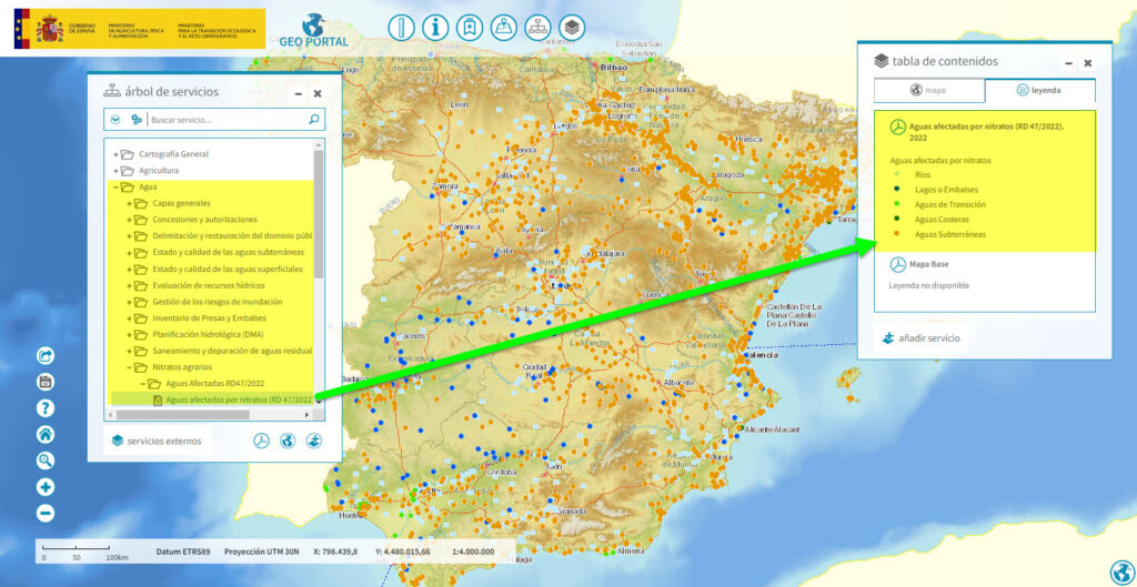
L’Équivalent Principal De Géoportail En Espagne
En Espagne, l’équivalent de Géoportail est proposé par l’Institut Géographique National Espagnol (IGN). Cette plateforme centralise les données géographiques et propose des outils cartographiques adaptés aux besoins des utilisateurs.
Présentation De l’Institut Géographique National Espagnol (IGN)
L’IGN, rattaché au ministère espagnol des Transports, de la Mobilité et du Programme Urbain, coordonne les informations géographiques officielles du pays. Il développe Geoportal Nacional, un service public destiné à la diffusion cartographique.
La plateforme Geoportal Nacional inclut des bases de données SIG, des cartes topographiques, et des images couvrant l’ensemble du territoire espagnol. Avec son interface multilingue, elle satisfait les requêtes des utilisateurs locaux et internationaux.
Fonctionnalités Offertes Par L’IGN
Geoportal Nacional propose plusieurs fonctionnalités interactives:
Cartographie dynamique : Accès à des cartes détaillées, images satellites, et vues panoramiques 360°.
Téléchargement de données : Exportation gratuite des données géographiques dans des formats tels que SHP, KML et GeoJSON.
Outils avancés : Mesures géospatiales, modélisation 3D, et superposition de couches thématiques.
Consultation des ressources historiques : Exploration des archives des cartes anciennes pour des recherches patrimoniales.
Ces outils facilitent l’analyse et la navigation géographique en Espagne.
Autres Plateformes Géographiques Disponibles En Espagne
L’Espagne propose plusieurs outils numériques pour l’exploration géographique. Outre Geoportal Nacional, différentes plateformes permettent d’accéder à des données interactives et spécifiques.
Visor SIGPAC
Le Visor SIGPAC (Sistema de Información Geográfica de Parcelas Agrícolas) fournit des informations précises liées aux parcelles agricoles. Il s’adresse en particulier aux agriculteurs, organismes administratifs et chercheurs. La plateforme offre des vues détaillées basées sur des données cadastrales, satellitaires et environnementales. Grâce à son interface, les utilisateurs peuvent consulter les limites des terrains, les types de cultures et d’autres éléments pertinents.
Plateformes Régionales Et Locales
Chaque région espagnole développe ses propres plateformes cartographiques pour répondre à des besoins spécifiques.
IDE Andalucía : Met à disposition des données sur le territoire andalou avec des options pour visualiser les reliefs ou consulter des ressources culturelles et naturelles.
SITIBSA (île Baléares) : Permet d’explorer des cartes avec des couches sur les infrastructures et la biodiversité locales.
GeoEuskadi (Pays basque) : Propose des outils riches pour l’analyse environnementale et urbaine dans cette région.
Ces plateformes régionales complètent l’offre nationale en fournissant des détails propres à chaque zone géographique. Elles aident aussi à élargir l’accès aux informations locales pour le public et les professionnels.
Comparaison Entre Géoportail Et Ses Équivalents Espagnols
Les plateformes Géoportail en France et Geoportal Nacional en Espagne offrent des outils puissants pour l’exploration des données géographiques. Cependant, des similitudes et des différences existent entre ces services.
Similitudes Et Différences
Géoportail et Geoportal Nacional partagent plusieurs fonctionnalités. Les deux plateformes permettent l’accès à des cartes interactives et des couches de données géographiques. Elles sont gérées par des institutions officielles : l’Institut National de l’Information Géographique et Forestière (IGN) pour Géoportail, et l’Institut Géographique National (IGN) pour Geoportal Nacional. Toutes deux offrent des outils de visualisation, comme les cartes 2D et 3D, ainsi que des ressources historiques.
Une différence notable réside dans l’intégration des plateformes locales en Espagne. En complément de Geoportal Nacional, diverses plateformes régionales, comme IDE Andalucía ou SITIBSA, répondent aux besoins spécifiques des utilisateurs en fournissant des données géographiques adaptées à leurs territoires. En revanche, Géoportail centralise toutes les informations géographiques françaises sur une seule plateforme nationale.
Avantages Et Limites
Géoportail propose une interface unifiée, ce qui facilite l’accès à des données variées. Les utilisateurs peuvent parcourir des informations sur l’ensemble du territoire français sans naviguer entre plusieurs sites. Cependant, cette centralisation limite l’accès à des données locales détaillées comparables aux plateformes régionales espagnoles.
Geoportal Nacional présente l’avantage de fournir des outils spécialisés pour des besoins spécifiques, notamment grâce à des plateformes comme SIGPAC, qui livre des informations détaillées sur les parcelles agricoles. Toutefois, les utilisateurs espagnols doivent souvent passer par plusieurs portails pour accéder à toutes les données pertinentes, ce qui peut compliquer le processus.
Les deux systèmes offrent des solutions performantes pour explorer les données géographiques, mais leur efficacité dépend des besoins spécifiques des utilisateurs.
L’Importance De Ces Outils Pour Les Utilisateurs
Ces plateformes offrent un accès rapide et précis aux données géographiques. Les utilisateurs peuvent consulter des cartes, explorer des territoires ou analyser des informations spécifiques comme les délimitations cadastrales ou les données topographiques.
Les chercheurs utilisent ces outils pour réaliser des études géospatiales. Ils intègrent des informations sur l’environnement, les infrastructures ou les activités humaines pour leurs projets. Geoportal Nacional et les autres plateformes espagnoles fournissent ainsi des données essentielles.
Les professionnels agricoles bénéficient de services comme le Visor SIGPAC. Ils identifient facilement les parcelles agricoles et vérifient les données liées à l’utilisation des terres. Ces informations facilitent la gestion des ressources et la planification des cultures.
Les citoyens accèdent à des cartes interactives pour des usages quotidiens. Ils planifient des itinéraires ou découvrent des lieux d’intérêt grâce aux fonctionnalités disponibles. Ces outils enrichissent leur connaissance du territoire.
Les autorités locales utilisent ces plateformes pour la gestion du territoire. Elles accèdent à des outils d’analyse pour l’aménagement urbain, la protection des espaces naturels ou les projets d’infrastructure.
Conclusion
Explorer les données géographiques devient essentiel dans un monde de plus en plus connecté. Les plateformes comme Geoportal Nacional en Espagne offrent des outils performants pour répondre à des besoins variés, qu’ils soient nationaux ou régionaux. Elles permettent une navigation enrichissante et adaptée aux spécificités du territoire.
Ces solutions numériques, qu’elles soient destinées aux professionnels ou aux citoyens, favorisent une meilleure compréhension des paysages et des ressources locales. En combinant innovation et accessibilité, elles jouent un rôle clé dans la gestion et la valorisation des territoires.
Trouver une parcelle précise peut parfois ressembler à chercher une aiguille dans une botte de foin, surtout quand on ne sait pas par où commencer. Heureusement, Géoportail simplifie cette tâche en offrant un outil puissant et accessible à tous. Que ce soit pour un projet immobilier, une étude de terrain ou par simple curiosité, ce service cartographique regorge de ressources pour explorer le territoire français.
Mais comment s’y retrouver parmi toutes ces fonctionnalités ? Avec une approche claire et quelques astuces, naviguer sur Géoportail devient un jeu d’enfant, même pour les débutants. Découvrez comment localiser rapidement une parcelle et tirer le meilleur parti de cet outil incontournable.
Qu’est-ce Que Géoportail ?
Géoportail est une plateforme cartographique en ligne développée par l’Institut National de l’Information Géographique et Forestière (IGN). Elle permet d’accéder à une large base de données géographiques couvrant l’ensemble du territoire français.
Elle réunit plusieurs types de cartes, comme les cartes topographiques, orthophotos, cadastrales, et historiques. Ces cartes servent à localiser des parcelles spécifiques et à visualiser des informations détaillées telles que les limites cadastrales, les bâtiments, ou les points d’intérêt.
Utilisant des technologies modernes, Géoportail propose des outils interactifs, tels que le zoom, les mesures de distances, ou la superposition de couches pour comparer différentes données géographiques. C’est un outil polyvalent pour les particuliers, professionnels, et chercheurs.
Pourquoi Utiliser Géoportail Pour Rechercher Une Parcelle ?
Accès à des données actualisées
Géoportail offre des cartes mises à jour régulièrement par l’IGN, garantissant une précision élevée pour l’identification des parcelles. Ces données incluent des informations cadastrales essentielles comme la délimitation des terrains ou les références parcellaires.
Large éventail de couches cartographiques
La plateforme permet la superposition de cartes topographiques, orthophotos et plans cadastraux. Par exemple, une couche cadastrale peut être combinée avec une carte aérienne pour une meilleure contextualisation.
Simplicité d’utilisation
L’interface intuitive du site facilite la recherche d’une parcelle. Les outils comme le zoom ou la recherche par adresse ou coordonnées géographiques simplifient le processus, même pour les non-experts.
Adéquation pour divers projets
Géoportail répond aux besoins de différents domaines, qu’il s’agisse d’achats immobiliers, de projets d’urbanisme ou d’études environnementales. Un utilisateur peut localiser une parcelle spécifique pour vérifier des caractéristiques comme la surface ou les limites légales.
Consultation gratuite
L’accès au service est gratuit, rendant Géoportail accessible à tous. Les utilisateurs peuvent examiner les données sans abonnement, contrairement à certaines plateformes privées.
Accéder À Géoportail
L’accès à Géoportail est rapide et simple. La plateforme propose une interface intuitive pour effectuer des recherches précises sur des parcelles et visualiser les informations géographiques associées.
Inscription Et Connexion
Géoportail ne nécessite aucune inscription pour accéder à ses fonctionnalités de base. Les utilisateurs peuvent consulter les cartes, rechercher des parcelles par adresse ou coordonnées, et explorer les couches cartographiques sans créer de compte.
Pour enregistrer des favoris, gérer des projets ou accéder à des outils avancés, il est possible de créer un compte gratuit. L’inscription demande uniquement une adresse e-mail valide et un mot de passe sécurisé. Une fois inscrit, l’utilisateur peut se connecter via l’onglet dédié en haut à droite de la page d’accueil.
Interface Principale Et Outils Disponibles
L’interface principale de Géoportail se divise en plusieurs sections. La carte interactive occupe l’essentiel de l’écran, permettant un zoom fluide et une exploration détaillée. Une barre de recherche en haut de la page permet de localiser une parcelle à l’aide d’une adresse ou de coordonnées GPS.
Sur le côté droit, une barre d’outils propose plusieurs options. Les utilisateurs peuvent ajouter ou supprimer des couches cartographiques, mesurer des distances, et dessiner directement sur la carte. L’outil “superposition” facilite l’affichage simultané de plusieurs couches comme les cartes cadastrales et les orthophotos. Des icônes claires guident l’utilisateur dans la personnalisation de l’affichage selon ses besoins.
Étapes Pour Rechercher Une Parcelle Sur Géoportail
Rechercher une parcelle sur Géoportail nécessite quelques étapes simples utilisant les outils intégrés à la plateforme. Les fonctionnalités accessibles facilitent la localisation d’une parcelle, qu’elle soit identifiée par adresse, référence cadastrale ou coordonnées géographiques.
Saisir Les Informations De La Parcelle
L’utilisateur begin par ouvrir la barre de recherche située en haut à gauche de l’interface. Il peut entrer une adresse complète, une référence cadastrale spécifique ou des coordonnées géographiques (latitude et longitude). Ces informations précises réduisent le champ de recherche et augmentent l’exactitude des résultats affichés.
Utiliser Les Couches Cartographiques
Les couches cartographiques permettent de visualiser différents types de données géographiques. En activant le menu “Paramètres de la carte”, l’utilisateur ajoute des couches spécifiques comme les cartes cadastrales ou orthophotos. Ces options aident à distinguer les limites et détails de la parcelle recherchée. La superposition de plusieurs couches donne une meilleure compréhension du terrain et de son environnement.
Exploiter Les Résultats De Recherche
Une fois les résultats affichés, l’utilisateur peut zoomer pour examiner les détails de la parcelle. Des outils intégrés, tels que la mesure de distances ou la création d’annotations, permettent d’exploiter ces données. L’option “Exporter” sauvegarde ces informations sous forme de fichiers pour des analyses ultérieures ou des projets spécifiques.
Conseils Et Astuces Pour Une Recherche Optimale
Utiliser des termes précis dans la barre de recherche
Saisir une adresse complète ou une référence cadastrale pour obtenir un résultat ciblé. Par exemple, inclure le code postal et numéro de parcelle réduit les résultats non pertinents.
Activer les couches cartographiques pertinentes
Sélectionner les couches comme “Parcelles cadastrales” ou “Cartes orthophotos” dans les options. Ces couches fournissent des détails visuels clairs des parcelles.
Utiliser l’outil de mesure
Cliquer sur l’outil de mesure pour calculer des distances ou des superficies. Cette fonctionnalité est utile pour évaluer la taille de la parcelle.
Zoomer et déplacer la carte avec précision
Ajuster le niveau de zoom et déplacer la carte pour un positionnement exact. Une vue plus rapprochée affiche des détails comme des bâtiments ou des limites de parcelles.
Sauvegarder et exporter les données
S’inscrire sur Géoportail pour sauvegarder des annotations et exporter les cartes en formats PDF ou image. Les utilisateurs non inscrits peuvent faire des captures d’écran pour conserver leurs recherches.
Limites Et Alternatives De Géoportail
Géoportail possède certaines limites qui peuvent réduire son utilité dans des cas spécifiques. L’absence de données en temps réel limite son usage pour des projets nécessitant des informations actualisées à la minute, comme le suivi des changements environnementaux instantanés. Bien que les cartes cadastrales soient détaillées, elles ne contiennent pas toujours les informations juridiques liées aux propriétés ou droits fonciers.
Certains utilisateurs peuvent trouver les outils avancés complexes sans formation préalable. Par ailleurs, l’exportation des données est limitée en termes de formats disponibles, rendant leur utilisation contraignante pour des analyses poussées dans des logiciels tiers. L’accès hors ligne est également absent, ce qui peut poser problème dans les zones à faible connectivité internet.
Alternatives À Géoportail
Plusieurs alternatives existent pour répondre aux limites de Géoportail. Google Earth offre une visualisation 3D et des données satellitaires mondiales, même si ses données cadastrales sont moins détaillées en France. Cadastre.gouv.fr permet de consulter des informations cadastrales officielles, incluant des références juridiques, mais sa cartographie n’est pas aussi interactive que Géoportail.
OpenStreetMap propose des cartes collaboratives avec des données souvent à jour, bien que sa couverture cadastrale soit limitée. Les SIG professionnels, tels que QGIS, permettent une analyse approfondie et personnalisée des cartes, à condition de maîtriser leur utilisation.
Conclusion
Géoportail se distingue comme un outil puissant et accessible pour localiser et analyser des parcelles en France. Avec sa richesse de données et ses fonctionnalités intuitives, il répond aux besoins variés des utilisateurs, qu’ils soient amateurs ou professionnels. Bien que certaines limites existent, ses avantages en font une ressource incontournable pour des projets cartographiques ou immobiliers. Pour une recherche optimale, l’utilisation des outils proposés et des couches adaptées reste essentielle.